A Bank Check That Flew 305 Miles
In November 1915, a tornado hit the town of Great Bend, Kansas. What happened next sounds made up. Debris rained down 80 miles away. A sack of flour turned up 110 miles away. And a cancelled check from the Great Bend bank landed in a field near Palmyra, Nebraska, 305 miles to the northeast.
Scientists call this debris fallout. The storms that make tornadoes can have updrafts faster than 240 km/h. Those winds can lift loose objects high into the parent storm and carry them a very long way. Waterspouts and tornadoes have even been put forward as an explanation for reports of fish and other animals raining from the sky.
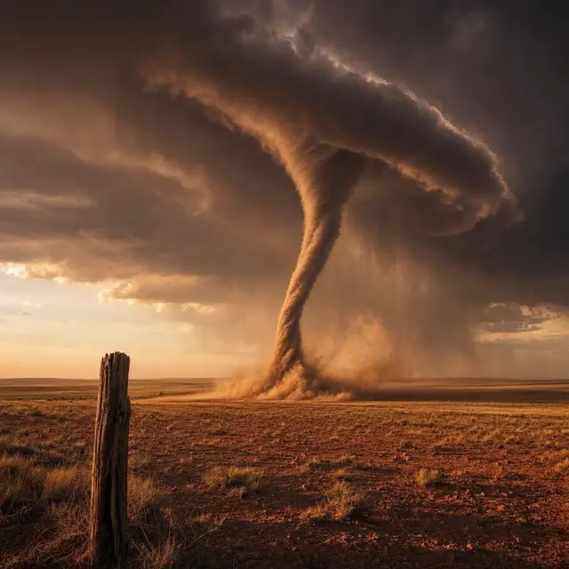
So what is a tornado, exactly? It is a fast-spinning column of air that stretches from the ground up to the base of a storm cloud. Most have winds under 180 km/h, are about 80 meters across, and travel a few kilometers before fading. The biggest ones break every one of those numbers.
Wedges, Ropes and Pink Funnels
Tornadoes come in more shapes than the classic funnel. A narrow, tube-like one with a low height is sometimes called a stovepipe. A huge one that looks wider than it is tall is a wedge tornado, and it can look like a dark block of cloud stuck into the ground. As a tornado fades, it often thins into a twisting rope. Some have two or more smaller swirls circling a shared center.
Their color depends on what they pick up. Tornadoes on the Great Plains can turn red from the reddish soil. Over snow they turn white, and a tornado crossing water, called a waterspout, can look white or even blue. Near sunset, tornadoes can glow yellow, orange and pink.
Size varies wildly too. One tornado left a damage path only 7 feet long. The widest on record, near El Reno, Oklahoma, on May 31, 2013, was about 2.6 miles wide. People describe the sound as a freight train, a waterfall or a nearby jet engine, while small ones can buzz like a swarm of bees.
Why the United States Gets the Most
The United States has more tornadoes than any other country, about 1,200 a year. That is nearly four times the estimate for all of Europe. The reason is geography. North America stretches from the tropics to the Arctic with no big east-west mountain range to keep the two apart.
The Rocky Mountains push dry air across the middle of the country, while the Gulf of Mexico feeds in warm, moist air from the south. Warm and cold air keep colliding, which breeds strong, long-lived storms. Much of this action happens in a central region nicknamed Tornado Alley, which reaches into Canada.
But here is a twist. The Netherlands and the United Kingdom record lots of tornadoes for their size, and the United Kingdom gets at least 34 a year, possibly 50. Most are weak and brief. Timing matters too. Worldwide, tornadoes peak around 5 pm local time, and they are most common in spring.
Rating a Storm by What It Breaks
Nobody can easily put a wind gauge inside a violent tornado. Normal instruments cannot survive the wind and flying debris. So tornadoes are rated by the damage they leave behind. The Enhanced Fujita scale, used in the United States since 2007, runs from EF0, which damages trees but not solid buildings, to EF5, which can rip buildings off their foundations.
Most tornadoes sit at the gentle end. In the United States, 80% are EF0 or EF1, and less than 1% are violent. There is a catch, though. A tornado crossing an empty field has little to damage, so it may be much stronger than its rating shows.
Mobile Doppler radar can get closer to the truth. In 1999, a tornado near Bridge Creek and Moore, Oklahoma, was clocked at about 486 km/h, the fastest wind speed ever logged. The record for distance belongs to the Tri-State Tornado of 1925, which stayed on the ground for 352 km across Missouri, Illinois and Indiana, for about three and a half hours.
Hooks on the Radar, Eyes on the Ground
Before the 1950s, the only way to detect a tornado was for someone to see it. The first public tornado warnings came in 1950. In 1953, scientists confirmed that a curled shape on radar, called a hook echo, was linked to tornadoes.
Today, Doppler radar can spot rotation in a storm from more than 160 km away. Most strong tornadoes grow from a special kind of thunderstorm called a supercell, which holds a rotating area a few kilometers up known as a mesocyclone. Radar can see those, but it cannot always see the tornado itself. That is why the United States has more than 230,000 trained Skywarn weather spotters watching the sky.
Even with all this, scientists still do not know exactly why some storms make tornadoes and others do not. Some old beliefs also fall apart under study. A green sky has no proven link to tornadoes. And opening windows does not protect a house. It may actually make the damage worse.