A Valley That Sits Below the Sea
The Danakil Depression is a large valley roughly 200 by 50 km across the north of the Afar Region of Ethiopia and Eritrea. It lies about 125 m below sea level, making it the third lowest-lying location on the continent of Africa.
It is boxed in on both sides. To the west rises the Ethiopian Plateau, and to the east the Danakil Alps, with the Red Sea waiting just beyond them. That barrier matters, because it is the only thing keeping the sea out.
Inside the depression sit several endorheic and saline lakes, including Lake Afdera, Lake Karum and Lake Bakili, which occupy volcano-tectonic hollows. There is no outflow to anywhere. Water that arrives here has one way to leave, which is upward, and what it leaves behind is salt.
Watching an Ocean Be Born
The depression is a rift, the northern tip of the Afar rift, formed by the Nubian plate and the Danakil microplate pulling apart. They separate at roughly 18 mm per year in the south of the depression and 8 mm per year in the north.
That process began about 11 million years ago with the counterclockwise rotation of the Danakil microplate. Since then, tectonic extension has thinned the crust and dropped the basin, letting sediments and volcanic rock pile in. Volcanic activity picked up sharply from at least 600,000 years ago, building the Erta Ale volcanic range.
Here is the striking part. The chemistry of the rocks in the Erta Ale range indicates there is no continental crust left underneath it, suggesting the Nubian and Danakil plates have already detached there. The rift is at an advanced stage, close to continental breakup. In October 2022 the IUGS added it to its list of 100 geological heritage sites for demonstrating "the ongoing birth of an ocean".
Dallol, the Acid Rainbow
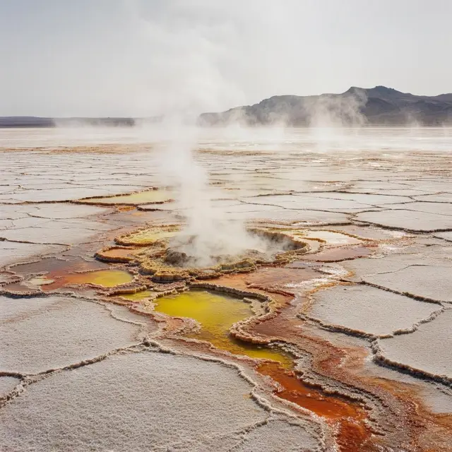
In the middle of the salt plain sits Dallol, a salt volcano rather than a conventional one. Magmatic fluids deep below interact with the thick salt deposits, dissolving them and driving them up to the surface.
What comes out is extremely acidic, extremely salty and hot. As those fluids oxidise, form compounds with iron and chlorine sulfates, and evaporate, they build up the vivid yellow, green and orange terraces the place is famous for. Biologists study it hunting for extremophiles, organisms that live in conditions normally fatal to life. They have found microorganisms in most of Dallol's ponds, though notably not right beside the hot chimneys where the fluids surface.
Nearby is Gaet'ale Pond, also called the Yellow Lake, a small hypersaline pool over a tectonic hot spring. At 43% salinity it is the saltiest water body on Earth. It is also very young: according to residents of Ahmed'ela village it appeared in January 2005, when an earthquake reactivated the spring beneath it.
Some of the Hottest Air Anyone Has Measured
The Danakil has a hot desert climate, with annual rainfall generally below 200 mm. The best-known long temperature record comes from Dallol between October 1960 and November 1966, giving an annual mean around 34.4 to 34.7 °C, a mean maximum of 41.2 °C and a reported peak of 45.7 °C.
Later fieldwork confirms the heat has not gone anywhere. Researchers report daytime temperatures routinely above 40 °C and summer temperatures reaching 50 °C or more, and during an October 2013 field campaign recorded a daytime air temperature of 54 °C. These are not directly comparable to the 1960s series, since they come from different periods, locations and instruments, and they describe Dallol specifically rather than the whole depression.
The valley has not always been this dry. During the Mid and Late Pleistocene the Red Sea flooded the basin at least four times, most recently around 130,000 years ago. The evidence is still lying there: fossil coral reefs, and evaporite deposits more than 500 m thick in the centre of the basin.